Showing posts with label Indain ruins. Show all posts

Saturday, November 26, 2016

The Comanche

Picture Canyon
            Situated in the SE corner of the state of Colorado is the Comanche Grasslands, owned by the Federal government.  The government bought up scores of acres and turned them is to grass in the attempts to slow down the dust bowl of the 30’s.  It also created recreational areas on the prairie, opening up wide variety public lands.  The nearby states also have huge sections of grasslands in the corners of their states. 
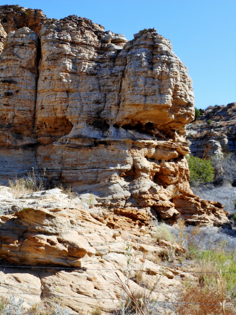
            The grasslands of New Mexico and Kansas encompass parts of the old Santa Fe Trail, following the Cimarron River, mostly dry.  There is the flat rolling land that is prone to blow and there is the surprise of the canyons and mesas in the area.  Just north of the Oklahoma border, in Colorado is a large area of land broken with canyons and rocky cliffs. 
            Tucked back in these areas are springs, trees and rocky overhangs, where the Indians could have shelter and carve in the rocks.  One such place is Picture Canyon, about 12 miles due west of Campo and a few miles south.  Here one drives out of the flat lands into scrub forest and rocky gulches. 

            The rock walls made great easels for early many.  The Indians left their mark with Pictographs and petroglyphs.  They were not alone the early European explorers left their mark also.  There are some petroglyphs that archeologists speculate may have been Viking/Celtic in origin.  Which raises the questions, were the Northern Europeans, exploring in Western North America. 

            No matter what, it is still a fun place to drive back into and watch the land change.  Looking at the cliffs, there are the occasional overhangs/caves that show signs of soot on the rocks.  Here in late summer the Indian could sit here and work his buffalo meat into pemmican.  For here in the canyons are a variety of fruits, Choke Cherry, Hackberry and others. 
            There are also the remains of cabins that were built, late 1800’s.  It was a good area to graze cattle for summer pasture and a cabin for the trail rider. 

            It is an area to delve back more than a few thousand years.  The Folsom Point man roamed the area, before the present day plains Indians showed up.  The Comanche Indians are the contemporary residents of the area, living, hunting, working and playing in the canyons.  

Saturday, January 10, 2015

Chaco Canyon


The Four Corners area of the US is loaded with ancient Indian mysteries.  Situated in the northwestern corner of New Mexico is Chaco Canyon one of the most extensive collections of ancient mysteries.  There was a variety in cultures that built there yet they are referred to as Anasazi Indians, a term meaning the “Ancient Ones.”  Not a tribe but a question mark and a label was hung on them for a reference point. 

img391 (1024x651)

Wandering through the area, there is a variety of construction styles.  The keyholes of Mexico, Cliff dwellings, Pit Houses, fine masonry work with chinking and large hewn stone work.  The styles indicating different tribal work or cultures. 

One thing that remains the same, the answers are no clearer then they were decades ago when I first visited.  The scientists still speculate on what they have found, based on the neighboring Pueblo Indians.  Even within them are a large variety of people and cultures.  So one can be a scientist and speculate and put their opinion forth as fact. 

img394 (653x1024)img396 (1024x682)img399 (1024x683)

I spent a week at Chaco over 30 years ago, pre digital and took hundreds of slides.  I have been scanning some of them and they bring sack moments from years past.  When I was there, an archeologist and some of his students were there excavating a set of pit houses.  I was able to visit with them and watch them work as they removed small pieces of various artifacts.  How they would remove parts from a fire pit to measure for dating.  The separation of various relics and how they recorded their finds.  They had traced this village of pit houses across the floor and about 600 years of evolution and their changes. 

img364 (1024x663)

This small group of houses was contemporary with the larger nearby Pueblo Bonito.  One of the speculations was that the Indians that inhabited these little huts were slaves of the Indians that were in the larger pueblo.  In the middle ages slavery was not unusual.  Capture weaker people, get them to build the large castle/pyramid and be the servants.  A recorded history is not available so theories are put forth based on other observations.  Then Indian slavery messes with the myth of the noble Indian. 

img358img367 (682x1024)img368 (1024x682)

Scattered across the area are hundreds of little villages.  Some are excavated, most are rubble piles.  Late 1800’s-early 1900’s the Wetherill brothers came out here and scrounged the Indian ruins.  Digging out pots and other artifacts, sending them back east for sale.  The sale of these ancient pots financed their diggings in the Four Corners area and kind of left an ugly scar on many of the ruin sites.  Lots of what the brothers recovered ended up in Europe and there was not much cataloguing of what was shipped where and where it was found. 

Yet there were enough untouched ruin sites, reconstruction has been pretty accurate and the stabilization helps to preserve the ruins.

img372 (1024x682)img374 (1024x682)

The Kivas are as varied as the rest of the canyon.  During the solstice and equinox they resonate with the visitors who have mystical aspirations of the ancient tribes. 

When I visited, the Sun Dagger had not been discovered.  Today many of the ruins sites are now called observatories.  The measurement of time was used with markers, noting the suns passing.  How sophisticated were these Indians?

img379 (1024x555)img382 (1024x653)img387 (1024x683)

The pictures are of organized rock piles.  In the day of occupation, the rocks were plastered.   Mud was applied to the walls, filling the chinks creating a well insulated dwelling.  The Kivas were decorated with sand paintings.  The archeologists found a Kiva with sand painting still on the walls.  With meticulous care, they peeled off 10 layers of different paintings covering a couple of centuries. 

A catch all category for the unknown is religious use.  And the kiva gets put into that category.  The items found in them become religious objects that were used in religious ceremonies.  It is interesting how things are labeled when they are not really sure.  It raises more questions and speculation.  Then that is the fun of the visit, then go to the museum of Anasazi history at the University.  Questions are cleared up and new ones arise. 

img358 (1024x682)

The park service has changed their perception and scope over the years.  Things that were talked about years ago are now gone for they mess with the myth that has been created.  Answers to the questions will probably never be found.  A mystery that many will look at and speculate on.  There is some substance and there is fiction t ofit an agenda.  Separate out the reality form the illusion. 

One of the collest collections of ghost towns to wander through and ponder.

Tuesday, April 1, 2014

The Ancient Dwellings of the Anasazi


Across the southwestern US is a large collection of ancient native Indian villages.  Most are abandoned and in various stages of ruins.  A few of these villages survived the Spanish invasion and are still inhabited by a few of the natives. 

In my travels I made it a point to visit as many of these old village sites as possible.  A few were National Parks, like Mesa Verde, others were National Monuments, like Canyon De Chelley, and some were State Parks.  The ones on federal land like the BLM were abused and very neglected.  Yet with good maps I could search these places out and have quite the adventure bounding over the dirt roads into lots of back country. 

I have been scanning some slides into digital and it has brought back lots of memories of these jaunts.  I met various Archeologists and Anthropologists during these visits and read lots of books about the Ancient Ones.  I had a good friend that was an Archeologist that had been on digs to Mexico and South America plus other places in the world.  We would sit on evenings when I would visit and talk about the all types of old stuff. 

Over time my appreciation for what I was looking at grew.  How the dwellings were constructed the purpose of the various rooms and how the Indians lived thousands of years ago. 

The recent slides I scanned were from Frijoles Canyon, just West of Santa Fe, New Mexico on the edge of the Los Alamos Caldera. 

The Bean Canyon is carved out of volcanic tuff and pumice, creating almost sheer walls in the canyon.  There was a small stream that flows through it providing water for the village.  It is off the beaten path so the number of visitors was low.

img254 (800x533)

Along the base of the cliffs, dwellings were carved out and houses were built using the cliffs as a wall. 

img260 (533x800)

Footholds were carved into the cliffs to climb out of the canyon.  Up the sheer rock they went.  Quite often it was from a rooftop.

img269 (800x533)

In some instances, a small portion would be constructed to show people what it looked like when the dwellings were inhabited.  Adobe blocks were made and used to build the walls, trees were cut for floors/roofs and covered with mud.  Up the cliff they would build, sometimes three, four stories or more. 

img268 (533x800)

Walls that were still standing were stabilized and held in place to preserve what little bit was left. 

img258 (800x533)

On the upper part of the cliff in a cave they built and over look which contained a Kiva, a ceremonial room.  There were no doors, only entry through the roof via the ladder.  Here were the drums, the pipes and other paraphernalia used for their various celebrations. 

Their culture is based somewhat on the present day Pueblo Indians, which they feel were their  ancestors. 

img255 (800x533)

Caves were dug into the cliffs behind the rooms.  The round holes in the rock were sockets fro holding the vigas after the walls were built.  Average height for these people was about five feet.  Most ceilings were just over six feet.

img272 (800x540)


Down in the canyon bottom they built.  South facing to catch the sun.  Water near by to water their crops of beans, corn and squash.  They were farmers, not hunter gathers. 

The canyon walls reveal the various layers of eruption from the volcano over the eons.