Saturday, November 11, 2017

Heartstrong, Colorado

Happyville, Colorado
            Scattered across the plains of Eastern Colorado, were a variety of Post Offices.  Most of the early ones were located in a farmhouse, that served a small community.  A general store would open and the Post Office would move but the town would keep the original name of the Post Office.  So when I saw the name Happyville on the map, all my assumptions went away.  During one of my trips across the prairie, I went looking for this village of happy folks.

            Didn’t find anything that looked like a town, It was more like a spot on the corner.  There was an abandoned church and nearby was a crumbling home and a few foundations.  The happy folks of Happyville had left.
            On a ridge nearby was another abandoned farmhouse where Heartstrong Post Office had been.  This area of southern Yuma County was pretty empty.  On distant horizon could be seen other dwellings.  Here at Happyville was empty building a memory of other times. 
            Heartstrong shows up on some weather maps, so it will be a spot on the map for times a coming. 


            Bouncing along CR 26, the dust boils up behind the pickup and reminders of yesteryear are few and far.  Yet during the early 1900’s, this was the promised land.  Here the settlers could have a piece of the dream and raise their family.  Here they could be happy.  

Sunday, November 5, 2017

Joliet, CO


Arlington, Colorado
           
            Arlington, began its life as a railroad camp on the Missouri Pacific RR, in Eastern Colorado.  The trains have stopped running and the rails collect rust.  No longer is there the clicking of wheels flashing over the tracks.  Cars and trucks can be heard rumbling along the highway that followed the rails to Pueblo. 
            There a couple of hardy ranchers that still call this little prairie burg home.  The Post Office closed and moved to Hasewell a few years back.  The roadside businesses are gone and the few store fronts are now silent.  The roadside park has a caretaker and the occasional traveler will stop for a moment.  Silence is the main companion for the few that pause.


            The main feature of the town is the schoolhouse that sits in far corner of the town.  The two story building dominates the land, yet years of neglect is showing.  Number of years ago some locals wanted to buy the school but the scrapper that owned it would not sell.  Today the junk that had littered the yard is gone except the tires left in the weeds.  The winds whistle through broken windows, the bell tower is sliest for the few birds and it appears that the school may be doomed. 

            The town has set vacant for so many years that the weeds dominate.  The few streets are overgrown and the remains of houses and building rise above them.  Street signs mark where the roads had once been.  Rooflines are barely visible in the overgrown town. 
            Yet someday the tracks may hear the clicking of wheels again.  A group wants to buy the rails but the transaction is held up in court and government agencies.  Arlington has no farming, most of that is to the east.  Trains would just pass through the remains of what once was on their way to Pueblo. 

            Nearby is a WWII auxiliary airstrip and little further is Adobe reservoir.  The canals today carry dust of yesteryear when the sugar beet ruled the country.  


Saturday, September 30, 2017

Vernon


Vernon, Colorado
            Located on the north central plains of Eastern Colorado, the little village has more memories on Main Street then pedestrians.  It is a country settler’s village that has hung on.  There are no major highways through town or a railroad.  Yet the town has maintained a small population of around 30 souls.  Main Street is empty, boarded up and the sidewalks are rolled up.  Down at the end of the road is the Post Office, there are enough residents in the area to keep it going. 


            For one weekend a year, Vernon comes to life, people stroll the town park, tractors pop and sputter and horses have the right of way.  Vernon Days is celebrated just before Labor Day.  It is a day to remember when their forefathers came into the area and homesteaded.  The few town folks roll out the old time carpet to celebrate yesteryears. 
            Otherwise the other 51 weekends are pretty noiseless as the sleepy little goes about life.  Surrounded by farmland, the whirr of farm equipment is more common the laughter of school children, from the now shuttered school house.  The little country church is well kept and hears the word on occasion.  The shops of Main Street remind one of when they could stop in and pick up supplies.  Across the street is the town park square, well groomed and cared for.


            Off in the distance on a ridge can be seen the community cemetery.  Looking at it one could see that the area was populous at one time.  Yet like so many prairie towns, the people left to try and find greener fields in the city. 


            Those that remain have different pace of life, the nearest towns with shops are miles away.  Sometimes the bus ride to school can be over 100 miles.  Yet the people take it in stride and live out a life from the land.  


Sunday, September 17, 2017

Carr Crossing, Colorado


Carr Crossing

Situated in the southern end of Lincoln County, Colorado, Carr Crossing was a community/rural Post Office during the early 1900’s.  For the visitor of today, it is some of the most empty land in the state.  Lincoln County is called a Frontier area, there aren’t enough people to qualify as rural.  Population density is less than one person per two square miles.  In the areas of Carr Crossing the density is probably 1 person per 10 square miles. 

Yet during the early 1900’s scores of people came out to this area to settle and homestead.  Scattered through the area are the sites of numerous empty and abandoned homes.  Moisture is extremely sparse and farming is almost impossible.  Today it is mostly range land with a few cattle grazing on the rolling hills.
The Car Crossing Post Office was located on a wagon road that overlooked the valley of Horse Creek.  Today there are no roads that go past it and way out there in the pasture is where it used to be.

The same is for the school, way out there in another pasture is where the school was located.  As the crow flies, it is about 5 miles from the PO to the school.  First time I visited the area, I had no idea there was a school because it was way off any road. 
When talking to some local people, they mentioned that the merry go round still sat out in the pasture form when the Carr Crossing School was teaching the children of the settlers.  So when I went through the area, I made it point to go looking a little closer to try and see the merry go round.

Driving down the road, I spotted a dead tree off in the distance sitting on a ridge and an outline next to it.   Pointing the camera off that direction and zooming way out, I snapped a couple of pics.  Sure enough there was the merry go round.  I tried finding a road to get closer but no luck.  So I have an ethereal picture of school playground out in the middle of a pasture, I would of never found if not for idle conversation. 
Carr Crossing is one of those places that will probably stay unexplored for decades because of their locations.  Then that is okay, I don’t know many people that like folks walking across their backyard. 


Here is an open area that has not changed much over the eons.  


Saturday, July 22, 2017

Song on the Land.

Heartsong, Colorado
            The name of a said, it would make a good song title.  Yet it is the name of a little village in Eastern Colorado that is no more.  Heartsong shows up on weather maps, so it had to of been a place at one time.  Doing some map searching, it showed up on satellite view as a collection of buildings.  Doing more searching an interesting story for the town came to light.

            Heartsong had its beginning in 1909 as Happyville.  1908 a settler homesteaded in the area and decided there should be a Post Office for the surrounding settlers.  Awarded the contract for mail service, Happyville was on its way to becoming a growing prairie town.  Stores and shops were built and when the auto showed up a gas station was added to the town. 
            Conflict arose between the founder and other settlers over the stores and various other arguments.  So the founding father got upset and threaded to move his stores to another location.  Sure enough, later that year, the stores and his house were loaded up and teams of 8 horses hauled the building down the road a few miles. 
            Leaving Happyville to a new location, called for a new name and Heartsong was chosen. The new town thrived, business was good.   Happyville became a ghost of itself and faded into not much.  The “Dirty Thirties” arrived, farmers were blown out and lost their farms.  With people moving out, Heartsong was in decline.  Then in 1940, fire struck the little village, burning up most of the town.  Heartsong disappeared into the ashes to be no more. 

            Today, there is a ranch where Heartsong once stood and at Happyville is an abandoned farm and nearby sits an empty church. The memories of the Prairie towns linger on with the people that survived the hardship of the land.  Farms dot the land, fields wave in the breeze and cattle watch the passing truck.


Saturday, June 24, 2017

River Bend, Colo


River Bend
            Situated on a bend in the river, the RR stop had a logical name of River Bend.  Today River Bend is a vacant spot in a pasture next to the railroad tracks.  The Interstate has an exit sign for the village that sat on the bend in the river.  Old River Bend, Colorado is back west from the Interstate exit a few miles behind the ridge.  Old highway 40 outline can still be seen following along the Interstate.  South of the exit are a few ranch houses, which is considered River Bend.  To the north on the hill is the town cemetery, a Boot Hill. 

            Outside of the exit sigh and cemetery, River Bend is a paragraph in most history books and sometimes only a sentence.  Yet in the 1870’s it was an important RR town on the plains of eastern Colorado.  Here the buffalo hunters arrived by railcar to safari into the nearby hills to hunt.  Colonel Reno used River Bend for his headquarters when General Custer’s 7th Calvary was assigned to protect the new railroad building across the plains. 
            As a result, River Bend was a pretty tumultuous town of saloons, brothels, and assorted characters.  With the various early day conflicts, boot hill had a good assortment of customers.  One of the locals at the museum talking about the cemeterary grimaced when describing some the evil folks buried up there on the hill. 

            In the area are remains of the stage stop, a military fort, ruts of the Smoky Hill Trail and assorted artifacts.  Metal Calvary buttons, Indian arrowheads, spent shell casings, wagon parts and rusted tin cans.  During the mid 1860’s, it was a crossroads for various trails/wagon roads going to the gold fields.  It also was great buffalo hunting grounds for the local Indians. 

            Flying down Interstate 70, River Bend exit doesn’t get much more than a glance.  The lone tree on Boot Hill, goes unnoticed.  Cattle dot the land, drifting along munching grass as cars and trucks whiz by.  It is a pretty quiet scene.  No more buffalo to hunt, no more Indians to do battle with and the gun fighters RIP. 


Saturday, June 10, 2017

Schoolhouse

Country School
Edison


            Driving across the plains of eastern Colorado, there is lots of empty land and one can see forever.  Building and trees on the horizon, generally mark farm houses or ranches.   This time the long empty road went past a schoolhouse.  For miles any direction, there were no tows, yet here there was a school complex.  Elementary, middle/jr high and high school and nice auditorium/gym, neatly groomed next to the gravel road in the middle of somewhere. 
            Farms and ranches have consolidated as more and more people leave the land and move to the city.  The few towns left behind, dry up and become memories of earlier days.  So the local families get together and consolidate their school districts into one.  There are still long bus rides, as much as 30-40-50 miles to school.  For some, it is better than a 100mile trip to the big town. 

            Edison school district is way out at the eastern end of El Paso county crossing into Lincoln County.  It is listed as being in Yoder, which is up the road about 15 miles.  Nearby is the town of Truckton and all around is lots of land to farm and ranch. 
            When towns disappear the folks get things worked out to educate their children.  Consolidated districts usually a variety of ghost towns/communities and the school house becomes a reminder of what once used to be.  What’s amazing, is the education in these little schools is just as good as it is in the big city. 
            The students in the country school don’t have the gangs to deal with or the noise of city life.  In the country classes are smaller, giving the students more personal attention.  There are sports programs, music, plays etc.  The school becomes a social center for all types of activities.


            Some homes are hauled in to provide housing for some of the teachers and small town kind of builds up.  Some of the locals will rent out to new teachers.  Sometimes the local are teachers and doing their farm and ranch work in the morning and evenings, through the summer.  The one room schoolhouse has been replaced by a sleek modern schoolhouse.  It has become a ghost town in reverse.  

Sunday, June 4, 2017

Stage Stop

Resolis Colorado
Resolis was a small town in Eastern Colorado, located on the banks of the Big Sandy Creek.  Today there is a road that winds through the area where the village once stood.  Its exact location is under debate and where the people say it was located is not a sure thing.  So Resolis may have been located there or maybe over there, one sure thing though, is, it did exist.
Resolis had its beginnings during the Colorado gold rush of the 1850’s.  A freight company in Leavenworth, Kansas was sending wagon trains of freight across the prairie to the gold fields.  In 1859 they formed the Leavenworth & Pike Peak Stage Line.  The stages used the route the freighters had been using to go to Denver.   In 1859 the LLP Stage line established a relay station at the crossing the Big Sandy.

Out in this pasture is where one of the locations for the town may of been.  

The stage line did not last long, in 1860 they were awarded the mail contract on the Overland route.  The route to Denver was abandoned but Resolis did not wither away.  The freight wagons were still rolling west and The Smoky Hill Trail passed through, keeping the trading post open.  During this time the population of Resolis had boomed to maybe 30 hardy souls. 
In 1870 there was another change to the area, the Kansas Pacific RR was pushing across Eastern Colorado.  The RR established a small RR town to the north of River Bend.  Many of the people of Resolis packed up and moved to the new railroad town. 
Here the road cross the former right of way, and is one of the places where the town was supposedly located. 

Resolis did not stay vacant for long because another railroad showed up in the area.  The Chicago, Rock Island and Pacific was pushing westward to Colorado Springs and at the site of Resolis a small depot was established for the new railroad.  People returned to the little village along the river banks.  There were jobs working on the railroad and it was good ranch land.  The population boomed again to over 60 souls.
Resolis now rivaled River Bend, its neighbor in size.  There were saloons, stores, blacksmith and all the amenities of a country town.  The land was not good for farming and when the Homestead Act changed very few people moved in to the area to settle it.  The ranchers pretty much controlled the surrounding area.
With the changes in railroading, jobs in the little section towns began to disappear.  The drought of the 30’s arrived and many people flew with the wind to other places and Resolis became a forgotten place full of vacancies. 
Some of the trestles still stand, to mark where the tracks had been.

When the railroad ceased operations in the 1970’s, a local RR began operations of a diner train through the area.  The big cottonwoods provided nice shade and cool breezes for the evening train to pass through.  Resolis was no more but it was a mile marker and listed in the RR time tables.  The diner train did not last long and when it ceased operations, the railroad also became a ghost. 

The rails were removed and the ROW went to various land holders in the area.  There are a few bridges still standing, the RR Grade can still be seen and a few ranch houses have some sizable fences of RR ties.  Yet where the town had exactly existed is a question.  One spot is out in a pasture, the other is where Resolis road cross the old ROW.  Oh well, bouncing down the road looking at what may have been, for on far horizon is River Bend’s Boot Hill.  

Sunday, May 14, 2017

Kuhn's Crossing


            One of those places where I was a few days late and a whole bunch short.  Situated off Hwy 94 and down a dead end road a short distance, was Kuhn’s Post Office.  This where one could cross Bijou Creek and continue their journey westward.  Off and on for years I drove past this location, not knowing what was located just over the rise. 

            Back in the trees lining the creek I could see a barn with its silo and the other ranch buildings.  It was a very pastoral scene as I whizzed by on the highway.  Back down the road had been Kuhn’s Crossing Schoolhouse and there were some log cabins. 
            Over the years these structures had weathered and collapsed into piles of lumber scrap heaps.  The markers of the little pioneer community were gone.  Down the road a ways were some ranch houses and outbuildings after crossing the creek.  A rubble heap sat on the ridge where the school had once been.  I took too long to go looking and found not much. 

            It is a fascinating area to drive through.  To the south a ways was a stage stop and a branch of the Smoky Hill Trail.  To the north on another road is another branch of the Smoky Hill Trail.  There are some other communities nearby and some wide open range land.  Cottonwoods line the creek bottoms and stately pines dot the ridges.  It is a varied land of rolling grasslands, towering ridges, 7000-8000 feet in elevation.  The Indians would roam here in the summer

            Today, many of the pine trees have grown back, ranches dot the land and cattle graze the grasses. 
This a picture in the Elbert County museum. 

Sunday, May 7, 2017

Elba Colorado

Elba


            The Elba Post Office was located at three different locations, according to the map.  There also was a cemetery that was named Elba, have seen no mention of a church.  Dotting the southern end of Washington County in Colorado, the Post Office slowly moved East until 1932 it was located on Hwy 63.
            The PO on Hwy 63 appears it may have been a small town of sorts.  There are a some buildings in the area and by its location may have been a general store with gad station.  The other locations were farm houses, back over that a way.

     Like many things on the prairie, Post Offices were consolidated into larger towns as the farms and ranches were consolidated into larger operations.  

     Today there is lots of open spaces between homes and mixed in the area are a few abandoned homes that are reminders of days gone past.  It is mostly farm land with some ranching in the rolling hills.  The occasional car streams by on the highway, a truck boils up dust on the country road.  There is a peace on the land as the wind is still that day.    
            The journey, following the roads on the old historic map, looking at the many building that sit vacant.  Empty homes, that hear voices no more, the birds that scatter with approaching stranger.  It is a land that still yields a harvest, provides for the people that still call it home. 

            On windswept plain is the cemetery.  Markers of when pioneers settled here.  A memory of when dreams of owning their own place brought them across the ocean, over the land.  Setting stakes and building their dream.  


Saturday, April 29, 2017

East on Hwy 36

Lindon Colorado
            Located in Eastern Colorado along US Route 36, Lindon is not as well known as its neighbor, Last Chance.  Lindon is a small country town that has almost disappeared.  All the businesses are gone.  There are enough people in the area to keep the post office open and it appears an old gas station is now operated as a garage. 

            The railroad never reached this far west, an omen of impending failure for the little community.  The droughts and unstable commodity prices for Ag products did not bode well for the settlers in the area.  Then the drought of the 30’s hit and the little towns began to blow away, including Lindon.  The school was closed and consolidated with a neighboring town. 
            There are a few who still call Lindon home, they are either ranchers, farmers or the hired hand.  There is the junk collector so common in small towns across the plains.  Along the highway, can be seen a few remains of where the various stores and shops had been.  The memorial to one of the local leaders is now boarded up, possibly due to vandalism.  There is the occasional car that whizzes by and the trucks that want to avoid the stops’ on the main byways.  Silence is the dominant feature of the little village. 

            On the map, the early Lindon post office is shown in five other locations and a variation of the spelling, Linden.  Two of the first post offices were located north of the neighboring town of Anton.  How the post office selected the contractors and why they changed is a good curiosity.  Two of the early mail stops were north of town and another was just south of the present town. 

            There are oil pumps in various spots in the area.  Lindon is on the southern end of the Julesburg basin and some good sized oil pockets have been found in the area.  This has helped to keep some life in the area, yet it has also contributed to the consolidation of farms and ranches in the area. 

            The nearest town for supplies is Anton, which is probably smaller then Lindon, both have a population of less then 50 souls, but Anton has the gas station/bulk plant, grocery store and elevator and a few other businesses.  With no rail service, everything is trucked out to the little towns along Hwy 36.  

Saturday, April 15, 2017

Dust Bowl Survivor

Campo Colorado


            Out along the prairie line approaching Oklahoma, is the little town of Campo.  The business district is mostly vacant and sitting collecting the dust of times gone past.  The corner café keeps Main Street from being completely empty.  It is a little town that probably will never perish because of its location.  It is a gateway to the Comanche Grasslands and on the busy Ports to Plains highway. 

            There is still a village government and the local constables keep the coffers from going empty.  Some people just don’t want to slow down passing through until they see the flashing lights.  Campo was also in the center of the dust bowl and a few reminders of those days are present.  There are a variety of pictures of the town and its neighbors from those dirty days.  Today the traffic flies by and the dust does not stop, it keeps on going someplace. 

            The empty store fronts on the road way harkens back to a day, when small towns were the heart of America.  Now the few ghosts sit under the canopy watching traffic pass.  The corner coffee shop has the local town news.  Pause for breakfast, listen to the locals cuss and discuss the weather or prices of crops.  The waitress hustles the coffee pot around, the cook yells, order up, and conversation goes on.

            Outside the trucks rumble by, shaking the ground as the press onward to their destination.  Nearby the rails sit silently, awaiting the next coal train to go south or returning empties.  The grain elevator sits in slow status of natural destruction.  A lone sentential next to the rails, a reminder of when business was on the railroad. 

            Over 100 hardy souls call the little prairie village home.  Working on farms or maybe one of the government jobs.  The grasslands are nearby and are operated under the Nation Forest Service.  Picnic grounds and trails dot the lands.  It is a land of mystery and surprises.  Petroglyphs have been found in some caves that some suspect may have been Viking.  There are the Indian artifacts spread around the areas, fossils, millions of years old and a herd of Big Horn Sheep call the grasslands home. 


            Campo will be a little wide spot on the road from here to there for years to come.  

Sunday, April 2, 2017

Prairie Question.

Buchannan, Colorado

           
Situated along a wagon road, is the dot marking Buchanan.  The map did not indicate that there had been a Post Office there.  Other information about this little dot on the map is slim and none.  It was in the area where I was driving, looking for ghost towns on the prairie.  So I bounced over a few ruts and went to see if there was anything at Buchannan. 

Up and over the hill I saw an old farm house and some out buildings, long abandoned.  The homestead sat on the banks of a small creek and it appeared there may have been some springs there also.  The house was small but functional.  Behind it was poles for a clothesline, a chicken coop.  Further down the bank was the barn and some posts for a corral and on the other side was the windmill and stock tank. 
It looked like any other homestead on the prairie that got blown out during the dirty thirties.  But here it was a dot on the wagon road.  So now I am speculating.  Was this a transfer point, way station for travelers, had there been a store here, what importance was the Buchannan place to the early day settlers.  I’ll probably never know, but I found the place.

Driving across the creek and looking back, I could see a faint trace of the old wagon road.  It was a change in the vegetation across the way on the banks of the small creek.  Straight as an arrow it headed for the Buchannan place. 
Nearby on the map, there were other places marked as having Post Offices.  Abbott was few miles south on the road and further south was the Abbott church.  Yet, here the road showed up, having its beginnings at Deertrail, CO. 

When I go searching for these prairie ghosts I usually have 4-8 targets marked out on the map.  Places like Buchannan are usually and after thought but being on the wagon road, intrigued me.  


Saturday, March 25, 2017

Down In the SE Corner


Vilas, Colorado
            A small village, located in the far southeastern corner of Colorado, near the Oklahoma Panhandle and Kansas border.  It has survived the Dust Bowl and the other farming downturns over the past century.  Founded in 1888, Vilas began life as a ranching community but with the flat rolling land, it soon became farm land.  Today it has a population of just over 100 hardy souls.  The school is still active and that is probably what keeps the little town going. 
            Main Street is vacant, lined with vacant stores from another era.  Even the garage and café appear to be closed.  The Post Office still flies the flag and the sounds of children echo across the village at recess time.  Otherwise one could hear a pin drop on the pavement leading into to town, it is that quiet and peaceful. 


The town sits a good distance off the highway and out there is where the grain elevators are located.  No longer do the rails get polished by trains.  The railroad stopped service some years ago. 
Vilas has become one of the wide spots on the highway from somewhere to over there.  Cars and trucks zoom past with the occasional local slowing down to go home. 


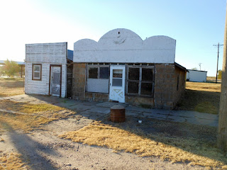
Vilas is becoming a classic ghost town, with a few residents.  Most of the store fronts along main are still standing, most overgrown with trees and weeds.  One of the stores has 1886 marked on its roofline.  It appears that most of the other stores lining the street were also built during the late 1800’s.  They are small, functional buildings and most around 400-600 square feet. 


In other towns, the old buildings on main street were burned down during a town fire.  Making the new stores bigger and usually made of brick.  In Vilas it appears there was not a major fire in downtown that burned up half of the town.  Here is a throwback to what many little towns on the prairie looked like during their early days.