Showing posts with label country roads. Show all posts

Saturday, September 11, 2021

Galatea, Colorao


Galatea, Colorado


Galatea was a Railroad town established by the Missouri Pacific railroad as it built west.  As the railroad moved across southern Colorado, they began naming their stops in alphabetical order.  And the G stop was named Galatea. 
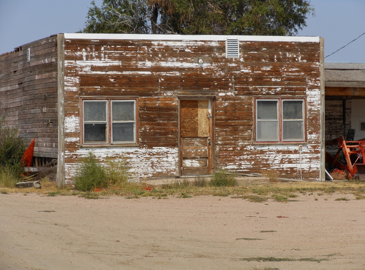
 

Like many of the RR stops, Galatea faded into memory.  A few building still stand on the former town site, along with some trees.   Out along the tracks are a few pieces of concrete where the depot, etc had been. 


Couple miles NE is the town cemetery and there are a few headstones among the overgrown weeds. 


Galatea is located in a dry harsh area and is not easy to eke out a living.  There are still a few souls that live in the area scratching a living from the dirt.  Yet the dirt blows real easy here and in spots are the drifts of blow dirt.  The rails had been silent for years, with a new owner, the iron wheels clatter over the rails again. 


The Missouri Pacific was not the first RR to go through the area.  In the 1870’s, the Kansas Pacific built a branch line through here on their way to Ft Lyon and the Pacific Ocean. 


The Arkansas Valley Railroad was short lived.  About ten years later the rails were pulled when the KP went into receivership.  During that time, freight traffic from the Santa Fe Trail was being loaded on the AV RR and going East.  Besides freight trains, there was the daily passenger train, it was a busy RR. 


Today there is no indication that another railroad had been the area.  The old right of way has been plowed up for farming.  Further north, towards Kit Carson, portions of the grade can still be seen in the pastures. 


Today the silence of Galatea is ruffled by the breezes that flow over the land.  The greeting committee is either the owl or the buzzard. 


Saturday, August 21, 2021

Ghost Post Office


Damascus, Colorado


Damascus, Colorado, was a small Post Office, operated out of a home at the turn of this past century.  The home site was located on the banks of Rush Creek in far south eastern Lincoln County. 


Out there in the ranchers pasture, among the trees a few structures can be seen.  Nearby is another ranch house and some barns and out buildings.  According to the old map, a wagon road went through the area, near Damascus.  It is a land of open spaces, Population density is maybe one person per 5 square miles. 


It appears the wagon road to Hugo, a railroad town during the 1899’s and 1900’s.  From Hugo, the mail and express was delivered to the ranchers in the area and maybe trading posts.  From Hugo, about 60 miles away, the drayage service would have delivered them mail to Damascus and other PO’s along the route. 


When I journeyed looking for Damascus, I had no expectations of what I would find and not much did I find.  I turned south from Boyero, making small dust cloud as I bounced along the dirt road.  About 4very miles or so I would pass a ranch house, otherwise it was open country.  Here an untouched land, much like when the buffalo roamed the prairie.  The only changes were the roads and fences.  The buffalo had been replaced by cattle to graze the grasses. 


There were scores of different birds, falcons, eagles, hawks, larks and you name em.  The occasional antelope could be seen on the ridges, watching the intruder, deer cautiously watcher the passer by, ground squirrels scurried off the road and coyote sauntered along the ditch.  Here was a land with few changes, so I settled in for the journey. 


Soon I was at my destination, well almost.  The road curved at the fence and beyond the fence went the ruts.  Over there in the trees was Damascus Post Office.  I followed the road around the curve and across Rush Creek.  There was a small trickle of water in the creek, some deer were lounging in the cool grasses on the banks.


I paused and did a 360 look about, There was a ranch house over there and some cattle were grazing over there and the breeze tickled the air.  It was day of time of wonderment.  The destination was at hand, the journey was the time spent thinking about past travelers. 


Damascus, Colorado, how came to be named that is still a mystery.


Sunday, July 11, 2021

Bakersfield


Bakersfield, Colorado

Bakersfield, CO, was a small country Post Office on the Plains of Eastern Colorado.   SW of Vona or SE of Seibert.  It served local farmers and ranchers, early 1900’s out of their house.  Where the map showed the location, there were a couple of homes.  One was an abandoned farm, now home to grazing cattle.  Nearby was an operating farm, with equipment and well kept yard.  The empty farmyard is probably where the PO was located. 


It is an area of rolling hills, of mostly pastures, with some farmland.  Cattle pause their browsing to look at the interloper, the buffalo have a look of curiosity and the deer and antelope scurry for cover and distance.  The fox and coyotes wander the area as do other critters.  Then there are the birds, Eastern Colorado has one of the largest, most diverse variety of birds in the state. 


Because it is mostly ranchland, the area is pretty empty.  Homes are few and far and the little country Post Office may have had a couple dozen customers. 


Nearby is the Mennonite community of New Fredericksburg. The church has been boarded up, but it appears the graveyard is still used and taken care of.   Probably there are still some ancestors in the area.


It is a land that holds memories of dreams from years ago. 


Sunday, October 25, 2020

Adena, Colorado


Adena, Colo.


The farming community of Adena, is located along the southern edge of Morgan County.  Not much can be found about this community but one can speculate based on similar places. 


Located on the banks of a small creek, there is not much left.  The one room school still stands and there are footers/foundations in the weeds and rubble.  The name Adena probably came from the settler that first had the post office contract for the area. 


From this small rural post office, the community probably grew.  The nearest town of any size is if about 30 miles away or better.  Besides the school, Adena probably had a general store to accommodate the post office.  May have been a blacksmith and when the autos showed up a gas station. 


Often there would be a community barn for hosting social events, card parties, dances, quilting bee’s… etc. To the north, about 3-4 miles, is the Adena community church, out back is small graveyard. 


Being along side of a creek, means it was downhill in the morning for the students.  In the afternoon, for the return walk home it was uphill.  Unless you home was downstream on the same creek. 


The farmers plow around the area where the community had been.  There are a few trees there plus the rubble.  The school will stand until it tumbles for it is not taxed.  The one room school had a few additions over the years.  The one room is now a two room.  So there was provably good sized settlement in the area at one time. 


Today the breezes float over the land, giving the birds currents to glide on. 


Sunday, October 4, 2020

Hoyt Colorado... Twice


Hoyt

Mom’s town

&

Sonnies


Hoyt, Colorado is a tale of two towns.  One in Kit Carson County, the other in Morgan County, the most familiar one. 


Doctor Hoyt was an enterprising gentleman, He developed two towns, neither really survived.  The one in Kit Carson County was built along the Hugo Wagon Road in the Republican River valley.  This town he named after himself, according to stories.  Doctor Hoyt’s town did not last very long.  The railroad came through to the south of town.  The townspeople wanted to be next to the rails.  So they picked up their town and moved it south a few miles. 


Meeting disappointment, Dr. Hoyt moved on, to the north.  In Morgan County, the ambitious doctor started another town, this one he named after his mother, Mrs. Hoyt, It appears the Mrs. was dropped.  According to stories, this Hoyt was established in 1904.  So a second Hoyt came into existence, it appears to of existed for a time.


Today Hoyt is an unincorporated village in the Platte Valley.  It is an assortment of neglected homes and farms.  There are still a few residents that call Hoyt home.  For well weathered building, Hoyt is a good place, for they have an extensive collection of old weathered stuff.


The other Hoyt is pretty vacant, there are footers and foundations that remind folks there were building there.  First Hoyt sits in private property, just off Hwy 59.


One thing, Hoyt’s name lives on. 


Sunday, August 9, 2020

Church Community


Shiloh


Shiloh was a small church community located in the Northwest section of Kit Carson County, CO.  The church still stands, in serious neglect and appears to of been abandoned more then 50 years ago.  Out behind is the graveyard, again neglected.  Weeds hide the markers and critters burrow here and there. 

It appears no descendents from the community still live in the area.  Steel pipes mark the edges of the graveyard to keep the farm from encroaching. 

The prairie winds flow unfettered thorough the roof and open windows.  Having withstood the elements over the decades the little tattered building is a reminder, when dreams and hopes filled the land.  Whispering winds filter through the open boards, rustling the memories of other times. 


Old farm machinery resides in the side yard
Old wooden plaster lath is revealed as time takes its toll on the church.

The out house has gone to rest in its repository.  


Saturday, May 2, 2020

Leader


Leader Colorado

Adams County is the community of Leader.  Being miles from any railroad, the store at Leader provided most everything for the settler.  The general store building still stands at the intersection of country roads.  It is a mixture of farmlands and pastures. 

Today there are maybe a half dozen homes in the area and the Leader Volunteer fire department, firehouse is next door. 


Yet this little corner store holds a hundred and one stories plus.  Early 1900’s, travel was by wagon and mule.  Average speed was about 4 miles per hour.  The limits of the settler to travel to the store on average, less than 12 miles.  For most it was 3-6miles. That means a trip to the store was around 3-6 hour journey.  Further then that would be an all day trip.

Here at the store, the settler would get his mail and or mail letters.   There would also, usually, be a blacksmith.  All the necessary stuff one could need was found at this little general store.

In the store there would be a clothing section, there would be boots and shoes.  There also would be the sewing section, so many wore homemade clothes.  There would be bolts of cloth, buttons, and patterns for shirts. Blouses, dresses, pants, thread, needles… etc.  In another corner would be a hardware section, nails, bolts, screws and other items, hinges, hasps and various tools.  At another counter, would be ammunition and guns.  It was for varmints, not many folks liked to have skunks or coyotes pay them a visit. 

Then there were the groceries, not like we see today.  It would be bags of staples, flour, sugar, coffee and supplies for canning or processing meat.  Most had a garden and canned their veggies.  Some would can their meat so canning jars and accessories were important. 

Flour sacks would be eyed for their pattern.  Would that color and pattern make a nice dress or blouse.  Selecting the flour bag was as important as the flour.  Home baked bread, rolls, or biscuits with a gravy was a staple.  Bags of beans would be purchased.  Various seasonings, salt was in a bag, pepper in a tin. 

The trip to the store was usually a monthly adventure and supplies would have to be bought to last for the month.  Many of the people in the area would have an account with the store and when their checks for their crops or livestock came in, bills were paid off. 

The general store was also news central.  The gossip would be plentiful when going into town.  They could also find out when the barn dances were, the funerals, the weddings and births. 

Way back then, it was a different way of life.  Many say it was hard, for them it was another day of life.  Here the folks from Europe had freedom from the tyranny of the royals.  They also had their own land, not the land of the kingdom. 
The little store building that still stands on the corner is a style I have seen for other stores out on the prairie.  It would be nice if some of these little store fronts would be saved.  One of the biggest things is to get them off the tax rolls.  That is the biggest reason so many of them are torn down, get out from under taxes.  There are special state funds for preservation of historic property.  People just have to be willing to jump through the hoops of the bureaucrats. 


Friday, April 24, 2020

Barry Post Office.


Barry Colorado

So often when I go looking for these little communities, I find a field.  The home that had housed the Post Office is no more.  It has been demolished and plowed over by the farmer that bought it.
That is pretty much what happened to Barry.  Early 1900, farmer Barry had a contract to host a Post Office in his home. The host farmer would keep it for a time then lose the contract for whatever reason.  Then another farmer would host the Post Office.  On occasion the Post Office would be consolidated into another or go to town.  There were so many variables on how the contract would change and or move.  I have managed to find a few ancestors that had some history on their local Post Office.  In one instance, the old Post Office contract was out bid by another local rancher.  So the Post Office was moved.  In another a town was formed and the town got the Post Office. 
In the case of Barry, I’m guessing the contract was awarded to another or farmer Barry went belly up.  Homesteading was not easy and there were failures.  Having a PO contract meant a few coins to help keep the family going but if the contract is lost, the farmer gives up and moves on in his life.
Whether there is anything left of the community Post Office is not of major importance to me.  I like the journey and the sights I find along the way.  There were a few abandoned ranches along the way, with big barns, some homestead remains and an assortment of rusty old equipment. 


At Barry though I got a treat.  At the road intersection there was a farmhouse across the road.  As I drove past, the dogs came out to greet me, chasing my pick up down the road.  I went across the road and turned around to take some pictures.  The dogs had arrived and not far behind was a four wheeler.  The dogs were friendly and as I was petting them a young man got off his ATV and came to say hi and see what I was doing. 
We stood there talking for a bit, he was 10-11 years old.  When I asked him why he wasn’t in school, he said it was spring break time.  Probably much like his father, as we were talking, the young man was looking out across the land.  A fairly common trait among country folks, they seldom look at the other person when talking.  The gaze roams over the land, checking things.  Here was this youngster being just like a man of the land.  What a contrast from city kids, he was well mannered, spoke to the subject and was very conversant.  The other thing was, all by himself, he drove the four wheeler and was very adept at it.  His father had probably restricted him to the ditch for it was well mowed.  That is where he had driven and parked it, walking across to the road to say hi. In the city, they don’t want their kids driving until the kids are old and gray.  What a contrast. 
Any way, it was an empty filed where the map had shown Barry to be.  I looked around, said good bye and was escorted down the road by the dogs. 

Barry is located in the NW corner of Kit Carson County.


Sunday, December 16, 2018

Woodrow School


Woodrow Schoolhouse

            The Woodrow schoolhouse is located to the south and west of the town of Woodrow.  A true country school, surrounded by prairie and farmland.  The land is now pretty empty, most of the farmhouse are gone.  There are a couple of farm homes nearby and the home of the folks that bought the old schoolhouse. 
            The building has set neglected for years and shows the wear.  Trees have sprouted up next to the foundation, windows are broken and the roof is crumbling. 
            In the late 40’s, oil was discovered in NE Colorado, the Julesburg Basin, that stretched into southern Washington County.  This oil boom provided some taxes for the local school districts and the folks of Woodrow got together with the people of Lindon.  They agreed to consolidate their schools and a new school was built in the pasture.  Woodrow School would be no more.  It would become a part of Woodlin School. 
            At the time the new Woodlin School was built, it was a state of the art facility.  Best equipment, school labs, classrooms, cafeteria and sports facility.  But the rural population decline did not halt.  The new consolidated school lost students and today it is a country struggle to keep things going.  Yet the country folks do not give up, their school is still their home pride and Woodlin is one of many schools out east that roll along, turning out some of the best students in the state. 
            The old Woodrow school building still stands, for how many more years is a question.  Like a waning beacon it stands on the prairie. 


Saturday, November 11, 2017

Heartstrong, Colorado

Happyville, Colorado
            Scattered across the plains of Eastern Colorado, were a variety of Post Offices.  Most of the early ones were located in a farmhouse, that served a small community.  A general store would open and the Post Office would move but the town would keep the original name of the Post Office.  So when I saw the name Happyville on the map, all my assumptions went away.  During one of my trips across the prairie, I went looking for this village of happy folks.

            Didn’t find anything that looked like a town, It was more like a spot on the corner.  There was an abandoned church and nearby was a crumbling home and a few foundations.  The happy folks of Happyville had left.
            On a ridge nearby was another abandoned farmhouse where Heartstrong Post Office had been.  This area of southern Yuma County was pretty empty.  On distant horizon could be seen other dwellings.  Here at Happyville was empty building a memory of other times. 
            Heartstrong shows up on some weather maps, so it will be a spot on the map for times a coming. 


            Bouncing along CR 26, the dust boils up behind the pickup and reminders of yesteryear are few and far.  Yet during the early 1900’s, this was the promised land.  Here the settlers could have a piece of the dream and raise their family.  Here they could be happy.  

Saturday, September 30, 2017

Vernon


Vernon, Colorado
            Located on the north central plains of Eastern Colorado, the little village has more memories on Main Street then pedestrians.  It is a country settler’s village that has hung on.  There are no major highways through town or a railroad.  Yet the town has maintained a small population of around 30 souls.  Main Street is empty, boarded up and the sidewalks are rolled up.  Down at the end of the road is the Post Office, there are enough residents in the area to keep it going. 


            For one weekend a year, Vernon comes to life, people stroll the town park, tractors pop and sputter and horses have the right of way.  Vernon Days is celebrated just before Labor Day.  It is a day to remember when their forefathers came into the area and homesteaded.  The few town folks roll out the old time carpet to celebrate yesteryears. 
            Otherwise the other 51 weekends are pretty noiseless as the sleepy little goes about life.  Surrounded by farmland, the whirr of farm equipment is more common the laughter of school children, from the now shuttered school house.  The little country church is well kept and hears the word on occasion.  The shops of Main Street remind one of when they could stop in and pick up supplies.  Across the street is the town park square, well groomed and cared for.


            Off in the distance on a ridge can be seen the community cemetery.  Looking at it one could see that the area was populous at one time.  Yet like so many prairie towns, the people left to try and find greener fields in the city. 


            Those that remain have different pace of life, the nearest towns with shops are miles away.  Sometimes the bus ride to school can be over 100 miles.  Yet the people take it in stride and live out a life from the land.  


Sunday, September 17, 2017

Carr Crossing, Colorado


Carr Crossing

Situated in the southern end of Lincoln County, Colorado, Carr Crossing was a community/rural Post Office during the early 1900’s.  For the visitor of today, it is some of the most empty land in the state.  Lincoln County is called a Frontier area, there aren’t enough people to qualify as rural.  Population density is less than one person per two square miles.  In the areas of Carr Crossing the density is probably 1 person per 10 square miles. 

Yet during the early 1900’s scores of people came out to this area to settle and homestead.  Scattered through the area are the sites of numerous empty and abandoned homes.  Moisture is extremely sparse and farming is almost impossible.  Today it is mostly range land with a few cattle grazing on the rolling hills.
The Car Crossing Post Office was located on a wagon road that overlooked the valley of Horse Creek.  Today there are no roads that go past it and way out there in the pasture is where it used to be.

The same is for the school, way out there in another pasture is where the school was located.  As the crow flies, it is about 5 miles from the PO to the school.  First time I visited the area, I had no idea there was a school because it was way off any road. 
When talking to some local people, they mentioned that the merry go round still sat out in the pasture form when the Carr Crossing School was teaching the children of the settlers.  So when I went through the area, I made it point to go looking a little closer to try and see the merry go round.

Driving down the road, I spotted a dead tree off in the distance sitting on a ridge and an outline next to it.   Pointing the camera off that direction and zooming way out, I snapped a couple of pics.  Sure enough there was the merry go round.  I tried finding a road to get closer but no luck.  So I have an ethereal picture of school playground out in the middle of a pasture, I would of never found if not for idle conversation. 
Carr Crossing is one of those places that will probably stay unexplored for decades because of their locations.  Then that is okay, I don’t know many people that like folks walking across their backyard. 


Here is an open area that has not changed much over the eons.  


Saturday, July 22, 2017

Song on the Land.

Heartsong, Colorado
            The name of a said, it would make a good song title.  Yet it is the name of a little village in Eastern Colorado that is no more.  Heartsong shows up on weather maps, so it had to of been a place at one time.  Doing some map searching, it showed up on satellite view as a collection of buildings.  Doing more searching an interesting story for the town came to light.

            Heartsong had its beginning in 1909 as Happyville.  1908 a settler homesteaded in the area and decided there should be a Post Office for the surrounding settlers.  Awarded the contract for mail service, Happyville was on its way to becoming a growing prairie town.  Stores and shops were built and when the auto showed up a gas station was added to the town. 
            Conflict arose between the founder and other settlers over the stores and various other arguments.  So the founding father got upset and threaded to move his stores to another location.  Sure enough, later that year, the stores and his house were loaded up and teams of 8 horses hauled the building down the road a few miles. 
            Leaving Happyville to a new location, called for a new name and Heartsong was chosen. The new town thrived, business was good.   Happyville became a ghost of itself and faded into not much.  The “Dirty Thirties” arrived, farmers were blown out and lost their farms.  With people moving out, Heartsong was in decline.  Then in 1940, fire struck the little village, burning up most of the town.  Heartsong disappeared into the ashes to be no more. 

            Today, there is a ranch where Heartsong once stood and at Happyville is an abandoned farm and nearby sits an empty church. The memories of the Prairie towns linger on with the people that survived the hardship of the land.  Farms dot the land, fields wave in the breeze and cattle watch the passing truck.