Sunday, October 25, 2020

Adena, Colorado


Adena, Colo.


The farming community of Adena, is located along the southern edge of Morgan County.  Not much can be found about this community but one can speculate based on similar places. 


Located on the banks of a small creek, there is not much left.  The one room school still stands and there are footers/foundations in the weeds and rubble.  The name Adena probably came from the settler that first had the post office contract for the area. 


From this small rural post office, the community probably grew.  The nearest town of any size is if about 30 miles away or better.  Besides the school, Adena probably had a general store to accommodate the post office.  May have been a blacksmith and when the autos showed up a gas station. 


Often there would be a community barn for hosting social events, card parties, dances, quilting bee’s… etc. To the north, about 3-4 miles, is the Adena community church, out back is small graveyard. 


Being along side of a creek, means it was downhill in the morning for the students.  In the afternoon, for the return walk home it was uphill.  Unless you home was downstream on the same creek. 


The farmers plow around the area where the community had been.  There are a few trees there plus the rubble.  The school will stand until it tumbles for it is not taxed.  The one room school had a few additions over the years.  The one room is now a two room.  So there was provably good sized settlement in the area at one time. 


Today the breezes float over the land, giving the birds currents to glide on. 


Sunday, October 4, 2020

Hoyt Colorado... Twice


Hoyt

Mom’s town

&

Sonnies


Hoyt, Colorado is a tale of two towns.  One in Kit Carson County, the other in Morgan County, the most familiar one. 


Doctor Hoyt was an enterprising gentleman, He developed two towns, neither really survived.  The one in Kit Carson County was built along the Hugo Wagon Road in the Republican River valley.  This town he named after himself, according to stories.  Doctor Hoyt’s town did not last very long.  The railroad came through to the south of town.  The townspeople wanted to be next to the rails.  So they picked up their town and moved it south a few miles. 


Meeting disappointment, Dr. Hoyt moved on, to the north.  In Morgan County, the ambitious doctor started another town, this one he named after his mother, Mrs. Hoyt, It appears the Mrs. was dropped.  According to stories, this Hoyt was established in 1904.  So a second Hoyt came into existence, it appears to of existed for a time.


Today Hoyt is an unincorporated village in the Platte Valley.  It is an assortment of neglected homes and farms.  There are still a few residents that call Hoyt home.  For well weathered building, Hoyt is a good place, for they have an extensive collection of old weathered stuff.


The other Hoyt is pretty vacant, there are footers and foundations that remind folks there were building there.  First Hoyt sits in private property, just off Hwy 59.


One thing, Hoyt’s name lives on. 


Sunday, September 27, 2020

Yesterday's School


School

In The Country


Scattered across the high plains of Colorado are variety of old country schools.  A few have survived and are still sitting on their spot.  Others have moved and have new uses.  This school appears to be sitting on its original spot and worse for wear.  Time and the elements are slowly bringing it back to nature. 


School districts were usually based on a township, 36 sections, one section set aside as school land.  Most school land was pasture land and the monies from its lease went to the school district.  That is probably why the building is still standing, it is not a tax liability.  It was probably built around 1915, plus or minus a few years. 


When it was constructed, there were few more folks in the area then today.  There were usually one family per half section but not all homesteaders made, had to sell out and move on.  That still would have left about 30 families in the district.   At the road intersection there could have been three families at the corner and more within a mile or two. 


What would of it been like to go to school here, more then a hundred years ago.  There would be no buses back then, so walking was the transport mode.  Maybe ride the horse bareback down to the fence and walk rest of the way.  Listen to the coyotes as you walk along, the distinct odor of the polecat, sidestep the rattler or maybe sing with the birds.   The winter all bundled up, trudge over the prairie, leaning into the wind, books tightly gripped.  There would have been path across the pasture or around the fields.  Look at the background of the picture and take a mile and half walk across the land.


There were no lunchrooms, so lunch was what the kids carried. Using a lard pail or wrapped in a cloth.  Food was homemade, nothing store bought.  There were no thermos bottles back then, so water or kool aid was the drink, often from a canteen. 


Mom and dad probably had not gone to school so homework the parents were learning with their children.  Often story time was one of the youngsters reading for the parents could not.  By the time the first one was in the 6th grade, mom and dad were usually pretty good readers and good at arithmetic.  Sixth grade was the graduation for most boys, a few girls went on to 6th.  The boys were to help dad with the farmwork.  With busses, the children could go into town and finish high school.  Most of the farm boys in WWII had only a sixth grade education. 


Sounds harsh, yet these youngsters survived and went on to be grandparents. 


Saturday, September 12, 2020

Shamrock


Shamrock Colorado


Located at the far eastern end of 104th ave, the town of Shamrock has almost disappeared.  The county has a road shop there and that pretty much keeps the little town on the map. 

When I went through the area years ago, there were a few buildings still standing.  Today, a schoolhouse is still there, the county building and a couple of homes.  The one room school is gone as are the other stores. 


The school house that still stands, appears to be a storage shed and well maintained.  Even the flag pole was in use, displaying Old Glory. 

South of the town is a WWII memorial, in the empty field.  During WWII a bomber training flight from Lowery crashed in the field.  A Memorial was built and dedicated to the crew of the crashed bomber.  It appears to have a caretaker, the flags are replaced and ground, cared for. 


Friday, August 21, 2020

Prairie Ghost town


Vona, Colorado


            Across the plains of eastern Colorado are many little burgs that are slowly settling in to dusty memories.  Early 1900 through the 1920’s these little towns were in their heyday.  Main street was a busy place with shops and stores in downtown.  Buggies and the new fangled horseless carriage shared the main avenue.  Then the great depression hit the country and life on the prairie would change for the depression ushered in the dust bowl.  What had once been prosperous land became pile of blowing dust.  No longer could folks pay their debts, banks foreclosed and people lost their livelihood. Life had evolved into a desperate situation of trying to survive. 

            Vona was located along the railroad line of the Rock Island.  When the homestead law changed, the little town of Vona was ready for the new settlers.  The railroad brought supplies and product was shipped via the railway.  Vona became a thriving farm town on the high plains.  A town government was formed and utilities were placed.  A school was built and into the 20th century Vona moved. 

            After the dirty 30, dreams began to fade and with the drought of the 50’s many sold out and moved on.  The dream of a country town began to fade into the murky recess of dreams lost. 

            Today Vona is home to a few dozen residents, but most of the business have closed up and moved on.  The Post Office is still open as is town hall to manage the utilities and streets.  City park is across the street from town hall and is maintained. 


            During the 60’s, Interstate 70 was under construction it completely by passed the little town.  The building of the Interstate was the knell of demise.  On the old highway, the gas station hung on until the caretakers could no longer manage.  The grain elevator shuttered up a couple of years earlier.  Across the corner is the junk dealer in the gulley with appliances strewn about awaiting the fate to the scrap pile. 

            Mani street has a few buildings, most are empty and store a variety of stuff.  One of the empty buildings had goats in a pen beside it.  Mostly the winds of past times float across the roofs whistling. 


            On a knoll overlooking the town is the water tower.  One of the more unique towers and probably one of the smallest tanks ever.  Next to it is a large steel tank, possibly auxiliary supply and behind is the new replacement water tower.  The old water tower was designated a historic land mark because of its uniqueness. 

            There are the few who still live in Vona, it is a quiet village, where people still go about life.


Sunday, August 9, 2020

Church Community


Shiloh


Shiloh was a small church community located in the Northwest section of Kit Carson County, CO.  The church still stands, in serious neglect and appears to of been abandoned more then 50 years ago.  Out behind is the graveyard, again neglected.  Weeds hide the markers and critters burrow here and there. 

It appears no descendents from the community still live in the area.  Steel pipes mark the edges of the graveyard to keep the farm from encroaching. 

The prairie winds flow unfettered thorough the roof and open windows.  Having withstood the elements over the decades the little tattered building is a reminder, when dreams and hopes filled the land.  Whispering winds filter through the open boards, rustling the memories of other times. 


Old farm machinery resides in the side yard
Old wooden plaster lath is revealed as time takes its toll on the church.

The out house has gone to rest in its repository.  


Saturday, July 25, 2020

RR Stop ... Kipling Colorado


Kipling, Colorado

          Kipling was a wannabe RR town, where not much happened.  When the Chicago Rock Island and Pacific built to the Rocky Mountain goldfields, it was also building towns along the way.  These little villages would become customers of the railroad and also provide a place for maintenance crews. 

          When Kipling was platted out, that was the purpose.  A section crew and control point.  A siding was put in along with a depot and control signals.  There probably was also a couple of house built for the RR crews to live in. 

          Kipling is located on the eastern banks of the Republican River, overlooking the valley.  There was a trading post down in the valley that wanted the railroad to stop there but stopping at the bottom of a hill is not what they want to do.  So the Rock Island put their stop on top of the hill.


          With the passing siding at Kipling, EB trains could build up extra steam for their run across the valley, Highball down hill and have enough momentum to easily climb up to the other side.  WB trains could pull into the siding and await the high flying EB. 

Today, there are not much of any reminders that there had been a little spot on the rails.  The signal lights lay in the weeds along side the rails and there is a country grade crossing of the rails. Traffic noise from the nearby Interstate rolls over the land, blending with the prairie breezes. 

Markers from the dirty 30’s still remain alongside the RR ROW.  The snow fence that had been built to protect the tracks is now buried under drifts of blow dirt.   Posts partially peering out of the drifted dirt. 

Besides the railroad going through the area, the Indians lived in the valley for generations.  Later the French would show up and begin trading with the Indians.  This area was part of the Louisiana Purchase.  The Spanish also traveled along the river, spying or checking on their neighbors. 

Next was the wagon road to the gold in the Rockies and then the Leavenworth Stage line, traveled the valley, with a stage station just below the ridge.  It had been a busy area, with a wide assortment of travelers.  Today the train still trundles down the rails, four a week and the occasional local passes thru. 

Add caption


Sunday, July 19, 2020

Carlisle Colorado PO


Carlisle Colorado

Carlisle was a small country Post Office, in operation during the early 1900’s.  On the map it is shown to be less than a mile from the RR community of Peconic. 

Operated out of a private residence, this little Post Office served the railroad workers and the few homesteaders in the area.  With a short spyglass, one can watch the jayhawkers floating on the far horizon in Kansas.

The Chicago, Rock Island and Pacific RR built through this area in 1888.   The RR designated the stop Peconic, but not much happened there.  The Post Office was located nearby since there were no homes in Peconic.  A grain elevator was eventually built, still no homes showed up. 

Down the rails to the East was the Post Office and more than likely it was a RR section house.  Keeping the RR operating was a labor intensive and sections were close together to keep the rails maintained. 

Today where the map shows where Carlisle was located is a grove of evergreens surrounded to by ag equipment.  There is an AG dealer located at the Peconic siding and a variety of cars are spotted there.  The grain elevator sits dormant. 

The cars and trucks whiz by on the Interstate as life in the farmland moves on.  Carlisle is pretty well forgotten and but a dot on an old history map. 


Sunday, July 12, 2020

Valley PO


The Valley Community


            The Valley Community shows two different locations for their Post Office in the NE corner of Kit Carson County.  One location is the far end of the county, next to the line with Washington/Yuma County.  The other is south about 5 miles, next to the Lincoln County line.  At the locations indicated on the map, there are no signs that anything had existed at these locations. 

            Rural Post Offices, like this were usually operated out of the farmer’s house.  Sometimes a store would arise, but for the most part, these little farm Post Offices would consolidate into a larger community. 


            With the arrival of the dirty 30’s many of these farms became vacant after being blown out.  Another farmer would buy it at auction and add it to his farm.  Over time the old farm building would be torn down and become farm land. 

            This is what appears to of happened to the building that housed the Valley PO’s.  The use of the valley name did not get lost.  Near one of the locations is the Valley Farm and Ranch.  Drive up over the ridge of one of the nearby farms is a small valley.  It appears a nice stream had flown through there at one time. 

            Before settlement, small streams and springs were quite common on the prairie of Eastern Colorado.  With settlement came tillage and water wells.  Much of this activity has directed the water to other places but with a heavy rain, some of these creeks still run.  It is amazing to see a dry sand creek full of water rushing down the valley. 


   Sprinkled in the area are a few farms and a few remains of farms and ranches that used to be.  The windmills still indicate where the water is and the gathering of the bovines.  Trees line the homes, many times hiding them in their cool shade.  Old equipment still dots the land and rolling pastures of grass. 

            Years ago an old wagon road sliced through this area, connecting trails in the south to the northern trails.  It is a land of flat fields to open rolling pastures with the occasional grove of trees. 


Saturday, June 20, 2020

The River of Tales


Purgatory Petroglyphs


            Walking gingerly over the boulder, Joe was looking downward as the boulder dropped off.  At the edge the incline was severe but Joe had his feet dug in.  Looking below saw the pathway he wanted.  The rubble pile from the avalanche stretched off in the distance but it was easy to skirt, just took some time.  Easing back up the slope of the boulder, Joe turned around to backtrack and begin a swing around the rock pile. 

            Off the boulder he scrambled, down the slope to where the pile of rocks ended.  Around the heap Joe walked.  Soon he was around the rocks and began scrambling over the loose rocks, carefully watching where he stepped.  These rock piles were notorious for snakes.  Stepping off the scree, his feet touched down on dirt.  Up the slope was a scramble to the crevice he could see between the boulders on the canyon wall.  Stepping around a house size boulder, Joe spied the path he was looking for.  A short ravine led back into the canyon wall.

            The rock path was damp from a small spring that oozed out from under the boulder.  The air was cooler from the dampness and ahead was the goal. 

            A whole wall of rock art, the Indians had came here for the cool spring and left their sign.  In the coolness of the small spring they could spend time chipping on the sandstone.  There were the circles, the deer, other animals, buffalo and signs of the spirits. 

            Going on back into the crevice, Joe discovered it was a cave, reaching back in the sandstone cliffs of the canyon.  Slipping the pack off, Joe mounted a miners lamp on his cap and took out a flashlight.  Putting the pack back on, he ventured on into the darkness.  Shining the flashlight on the walls revealed paintings.  The Indians had been in here and from the light of the fire had marked the walls.  Most were faded yet a few glowed in the light.  Pulse was rushing, heart was pounding, a treasure trove of ancient Indian art covered the rocks on the caves entrance.  Round and round the flashlight traveled, revealing all types of petro glyphs and pictographs from centuries ago. 


            On into the cave Joe walked, to see what was deeper inside.  A rock out cropping narrowed the entrance and Joe had to turn sideways to get around the rock.  As he stepped past the out cropping a cold wind whistled past him.  Shirt was waving and hair was standing on end.  Taking another step the wind ended and there was a cool breeze coming from the right.  Shining the light that direction, there was a small opening between the rocks.  Getting on knees, Joe shined the light into the opening.  Darkness was revealed until there was a glint flashing back at him. 

Waving the flashlight around the glint stayed there.  Now it was curious, what was causing the reflection.  On hand and knees he could crawl into the opening.  Turning on the miner’s lamp, Joe got down and began crawling into the unknown.  Cool air wafted past him, feeling good after being the hot sun most of the day. 

            A short distance in, Joe stopped, hair stood on end, he blanched, fear rolled over him.  Out of the opening a wail began, the moan of a crying woman.  Backwards Joe began to try and scramble but it wasn’t fast enough.  The low moaning built into a shrill cry, growing ever louder.  Ears were on fire from the noise.  Out of the small opening Joe scrambled as the scream reached ear piercing levels.  Running to the daylight of the cave opening, both ears covered trying to block the pain.  Out into daylight he popped.  Eyes bulged out, face white and ears covered. 

            In the daylight the scream subsided to a low wail.  Collapsing on the ground, Joe lay there.  Breathing going full throttle, ears throbbing from pain.  Passed out, he laid there.

            Coming back to consciousness, Joe groaned, rubbed his ears, looked at a now dim sky.  The sun was setting when Joe came around, shadows were long.  Sitting up, he looked around, the ground was damp where he had lain, below were piles of rocks, above were huge boulders.  Where am I, What happened, Joe was mumbling to himself. 

            There was no crevice nearby, no openings in the cliff and no rock fall.  Over there he could see his truck, beside him was his pack.  On his cap was the miner’s lamp and on the ground was the flashlight.  Stunned he looked around in disbelief, how did I get here, he asks himself. 

            There is only a dim memory of Joe scrambling over the boulders, climbing into the crevasse, finding the petroglyphs and the cave.  Then the wave of the screaming rolled over Joe’s foggy thoughts.  Covering his ears, he grimaces in pain as painful memories flood over.  Soon the ache subsides and he looks around again, not recognizing anything.  In a stupor, Joe sits there.  Thoughts are going 100 gazillion per second.  Head is ringing, the mother of all hangovers.  Turning eyes, twist around to survey the scene.  Everything is off kilter.  Joe looks at himself, asking, what happened to me.

            In a daze, Joe stumbles to his pick up, finds the water and sits down.  Taking sips, the cob webs become fuzzy.  Few more drinks and the fuzzier become clear.  Collecting the thoughts of a rambling mind, Joe accesses his situation.  Walking back to his pack, he picks it up, puts the flashlight in and lugs it back to the truck.  Into the cab he tosses the pack.  Going around to the other side Joe crawls under the steering wheel.  The motor roars to life.  Easing into gear, Joe begins a puzzled trip home. 


Saturday, May 23, 2020

Beaver Valley


The community
Of
Beaver Valley

At the far eastern edge of Colorado’s central plains was a small settlement community called Beaver Valley.  To the east can be seen the sunflowers of the jayhawk state. 
When I first heard of this area, I was in anticipation of a place on the bluffs overlooking one of the many sand creeks that roll over the plains.   Instead I found a land of table flatness and one of the most tranquil peaceful spots on the open prairie. 
There are still a few farms in the area but what really stands out is the cemetery.  Eastern Colorado is not known for its trees, yet the folks of Beaver Valley planted a trove of pine trees.  The cemetery boundary is a line of pine trees.  Today they reach to the sky, providing a moment of solitude. 
The trees provide shelter for the local wildlife.  The day I was there, the birds were chattering a flitting about.  Gathering nesting materials, looking for food and chattering among themselves.  As I walked about, looking and taking pictures, the birds would let me know if I was to close to their tree.


The breezes whispered through the branches, singing the song of the plains.  All other sounds were mute and unheard.  I sat in my pickup and had lunch while listening to the various birds chirping.  It was one of those moments where the world was at peace. 
My gaze rolled over the scene, taking in the grandeur of the area.   Here was one of the most peaceful places for a final rest.  A view out a across an unbroken land with no end of the horizon. 

Saturday, May 16, 2020

Empty Ranch


Ranch on the River

            Wandering along the dirt roads leads to adventure, hopefully.  Any this roaming trip took me to an unusual setting.  A ranch house that was sitting on the edge of the river.  Not up on the banks like most homes but down next to the river.  Today it doesn’t look like much of a river.  Much of the Republican River has dried up in Eastern Colorado.  Prior to 1900 the Republican was gushing little stream flowing over the plains.  With water wells, farming much of the water for springs has went other places.  The drought of a few years ago did not help, many of the springs dried up and have not came back.
            Years ago the river would flood from severe rainstorms and water would stretch across the valley in a raging torrent.  The flood of 1935 was probably one of the nastiest floods on the prairie.  In some places the river was three to four miles wide and 50-100 feet deep.  Washing away homes, animals and anything not real secure.  Looking at the river today it would be hard to imagine a torrent stretching across the way to the far hills side.  The flood waters were probably lapping at the edge of the little house on the river.
            The Republican was the highway for the early European explorers.  The Indians had been traveling along these routes for centuries, so when they guided the white man, they followed their known trails.  This area of Eastern Colorado was a part of the Louisiana Purchase.  Early 1600’s the French had established a trading post in Western Nebraska on the Republican River.  Along the river the French trappers could follow, trapping and trading with the locals. 
            The French Territory, butted up next to Spanish lands.   The Spainish would send out patrols to check on the French.  Traveling north out of New Mexico, the Spanish would use the Republican River route to journey to the French outpost in Nebraska.  What looks like barren void country today, centuries ago was a busy route on the plains.  As more explorers showed up, the river route became a busy thoroughfare across the empty land. 
            After the Louisiana Purchase, Lieutenant Zebulon Pike followed the Republican River across Kansas into present day Colorado.  Eventually this portion of the river would be the route the Leavenworth and Pikes Peak Stage lines would use.  The Stage line operated coaches in pairs with teams of four mules hauling the coaches across the country. 
            Along the river the stage line operated numerous stage stations the keep the mules fresh and the coaches moving westward.  If you could go back in time to 1859 you would of probably met Horace Greely on his westward sage ride through here.  They also operated freight trains along the river road.  50-100 wagons could be seen on occasion trekking along the wagon road.  They would be pulled with oxen, a draught of two yoke of ox and the bullwhacker.  Steadily the freight would move over the land, the bullwhacker silently walking beside his double yoke of ox.  There would be a small herd of extra oxen and men traveling along with the wagons.  Conjure up and image when the train would stop for camp. 
            With the advent of more railroads crossing the land, wagon roads like this became obsolete and are now but in memories.

Saturday, May 2, 2020

Leader


Leader Colorado

Adams 
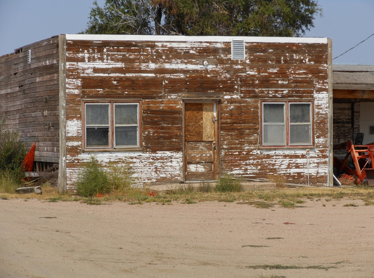
County is the community of Leader.  Being miles from any railroad, the store at Leader provided most everything for the settler.  The general store building still stands at the intersection of country roads.  It is a mixture of farmlands and pastures. 

Today there are maybe a half dozen homes in the area and the Leader Volunteer fire department, firehouse is next door. 


Yet this little corner store holds a hundred and one stories plus.  Early 1900’s, travel was by wagon and mule.  Average speed was about 4 miles per hour.  The limits of the settler to travel to the store on average, less than 12 miles.  For most it was 3-6miles. That means a trip to the store was around 3-6 hour journey.  Further then that would be an all day trip.

Here at the store, the settler would get his mail and or mail letters.   There would also, usually, be a blacksmith.  All the necessary stuff one could need was found at this little general store.

In the store there would be a clothing section, there would be boots and shoes.  There also would be the sewing section, so many wore homemade clothes.  There would be bolts of cloth, buttons, and patterns for shirts. Blouses, dresses, pants, thread, needles… etc.  In another corner would be a hardware section, nails, bolts, screws and other items, hinges, hasps and various tools.  At another counter, would be ammunition and guns.  It was for varmints, not many folks liked to have skunks or coyotes pay them a visit. 

Then there were the groceries, not like we see today.  It would be bags of staples, flour, sugar, coffee and supplies for canning or processing meat.  Most had a garden and canned their veggies.  Some would can their meat so canning jars and accessories were important. 

Flour sacks would be eyed for their pattern.  Would that color and pattern make a nice dress or blouse.  Selecting the flour bag was as important as the flour.  Home baked bread, rolls, or biscuits with a gravy was a staple.  Bags of beans would be purchased.  Various seasonings, salt was in a bag, pepper in a tin. 

The trip to the store was usually a monthly adventure and supplies would have to be bought to last for the month.  Many of the people in the area would have an account with the store and when their checks for their crops or livestock came in, bills were paid off. 

The general store was also news central.  The gossip would be plentiful when going into town.  They could also find out when the barn dances were, the funerals, the weddings and births. 

Way back then, it was a different way of life.  Many say it was hard, for them it was another day of life.  Here the folks from Europe had freedom from the tyranny of the royals.  They also had their own land, not the land of the kingdom. 
The little store building that still stands on the corner is a style I have seen for other stores out on the prairie.  It would be nice if some of these little store fronts would be saved.  One of the biggest things is to get them off the tax rolls.  That is the biggest reason so many of them are torn down, get out from under taxes.  There are special state funds for preservation of historic property.  People just have to be willing to jump through the hoops of the bureaucrats.